Good drilling practices alone won’t save wells experiencing collapse issues, but creating accurate Geomechanics models, and continuously upgrading those models, will.
Regardless of where in the world a client’s drilling operations are, it is critical to design a drilling program that matches the rock. That’s seems pretty simple, but the truth of it is, it is not uncommon for some operators to plan their drill sites solely off of topography, and not off of downhole rock mechanics. That is not an indictment of the drilling team – in many cases, they get handed the location and are forced to begin planning wells before the geomechanics studies are even complete, and by the time they are, they are so far down the road with AFE’s and site plans and even roads, they really can’t back out and move the pad two miles in the opposite direction. They are forced to drill at whatever angle and azimuth will hit the target.
But not all angles and azimuths are created equal…
Here’s an example. A client of ours bought a project that had been started by another company. There is an existing pad from which to drill from, and all of the wells drilled so far have been to the NE. Pretty good wells, some issues, but nothing that couldn’t be worked through. The problem came when the wells to the NW hit the schedule – BHA after BHA, left in the ground… Why? Because that direction, and the angles needed to cover that part of the field, required significantly more mw and different designs than the wells to the NE. It became obvious, right from the start, that “good drilling practices” alone won’t save wells experiencing collapse issues, but creating accurate Geomechanics models, and continuously upgrading those models, will.
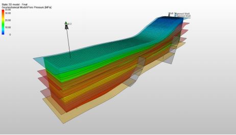
Benefits of 3D Geomechanics Models
Ability to Tie-In Entire Field
What HXR has found while doing 1D models for individual wells is that some tend to “act” the same way, and others don’t. This is intuitive (ever been on a project where the wells in one direction produce better because they cross-cut the natural fractures, versus wells in another direction that don’t?), but hard to put into practice because it may mean different size casing in one area versus another, or a different hole size – in other words, the logistics in making changes becomes difficult. Couple that with the tendency for geology to not talk with drilling, and you potentially have a recipe for disaster. 3D modeling allows us to model the stresses across the field and identify/classify wells by what it will take to drill them. You can PLAN for X well, on the schedule 6 months from now, to require a certain mw or a certain casing point, which well Y, on the schedule in 10 months, may not need. It also helps with other types of future planning, such as:
- New pad or platform placement
- Redesign of the pattern of wells to be drilled from a given platform. Maybe simply drilling 45 degrees off, and then turning them in the target zone will save millions in potential NPT?
Break out Individual Fault Blocks
A solid 3D model showing the various fault blocks will allow us to not only plan casing points but also to ensure no oil is being stranded.
- Important to note that, as unfortunate as it may be, to ensure success, we may have to specialize well designs; some may need 4 strings, some may need 5, depending on whether or not we have to cross fault blocks with significant stress changes in the same section. For example, say we are accustomed to drilling a 12.25” section through a certain formation for 15000’. That may be possible within a fault block; if we cross from one that is primarily normal-fault regime into one that is strike-slip or possibly thrust-fault regime, a 3D model will allow us to know that, and plan for it accordingly.
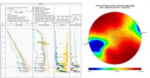
Simplifies Drilling Program
Outputs from the 3D model along the proposed wellpath will easily and accurately define PP/CP/FP and MW window needed. Will also allow for constraints to be put upon wellpath inc/azi.
Allows for Easier Sharing of Information Between Other Operating Departments
HXR has found that, even between different departments, let alone other companies, clients spend a significant amount of time “reinventing the wheel”. Lessons Learned, whether it be Geo or ERD, are not communicated well across the individual departments tasked with coming up with a well plan. A 3D model allows for wells drilled into a previously untapped area to benefit from the information accumulated from all of the other wells nearby. And do it graphically, where there is no misunderstanding.
Cost Effective
Having one centralized model can save millions in time and individual modeling costs. Having one model has the added benefit of allowing all involved to collaborate and build upon the single model, instead of building their own partial models which will inherently be more inaccurate, since not all of the wells drilled will be part of it. HXR can help your team build, and maintain, those models.
Logging Programs
Easier to know what type of a logging program is needed in a certain area of the field.
Posted on: May 12th, 2016
Filed under: Blog, Geomechanics, Well Design